A burned-out town in the middle of nowhere, beautiful conservation lands, and a piece of Watertown in … Weymouth?
We’ve been told over and over again over the past few weeks that if you’re going to get out for some exercise, it’s best to stay away from crowds of people as well as overflowing parking lots. This is good advice, as we are now in the heart of the pandemic and “social distancing” is more important than ever.
But this doesn’t mean you have to stay indoors or pace back and forth in your yard or on your balcony; as mentioned in my last hike update, there are plenty of conservation areas that no one seems to go to, and some are so remote that it’s best to find one or two others to go with just so you don’t get creeped out by the sheer isolation. One such place even encompasses parts of three communities—Rockland, Abington, and Weymouth on the South Shore—and is one of the most unusual spaces in the entire Greater Boston area in that it includes several very quiet and peaceful sections, and a “neighborhood” that will leave you scratching your head, but more on that in a bit.
Unlike some conservation areas that are pretty straightforward and easy to figure out such as the Middlesex Fells and the Blue Hills (both of which have been extremely crowded of late, by the way), the area being looked at here includes pieces of several connected properties including Rockland Town Forest, a bird sanctuary that’s within the forest, Twin Ponds, Thompson Pond, Southfield/Union Point, and … East Watertown? Again, more on this last part later on, so hold that thought.
Perhaps the best place to start the hike is at the very southern tip in Rockland, and if you have a car, it’s easy to get to—take Route 18 south from Route 3 to North Abington, where you take a left and drive just under a mile to the Rockland Town Forest entrance on the left. If you don’t have a car, it’s still pretty easy to get to; from the commuter rail stop in Abington it’s about a mile-and-a-half walk via Route 58 north to Route 139 east.
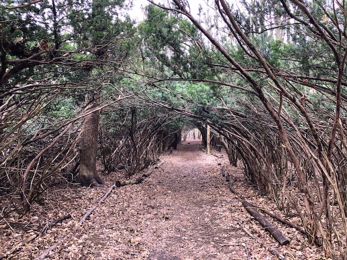
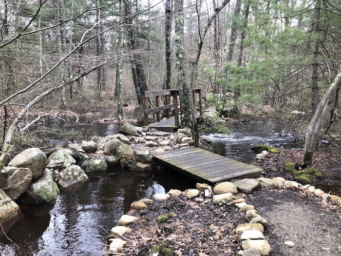
When you get to the Rockland Town Forest parking lot, look for a sign that points to the bird sanctuary. Within a minute or two, you’ll be on a remarkable trail with an umbrella of trees shutting out all sunlight and having (depending on the season) countless birds singing and flying around. This is a very peaceful space and it only gets more so as you work your way northward through the town forest via the Albert L Ingeno trail, getting deeper and deeper into the woods with boardwalks and bridges going over marshes, streams, and little waterfalls, and feeling almost like a scene from Lord of the Rings.
Rockland Town Forest is a wonderful place that few know about, and you could probably just do this area and be happy in doing so, but more conservation areas await, so continue northward to the end of the trail at Spruce Street near the Rockland-Abington line.
From this point, take a left on Spruce Street and walk a few hundred feet to another parking area which marks the start of two more hiking spots—Twin Ponds and Thompson Pond. These conservation areas are basically bookends, with one on the right and the other on the left, and for the sake of simplicity, going counterclockwise might work best here.
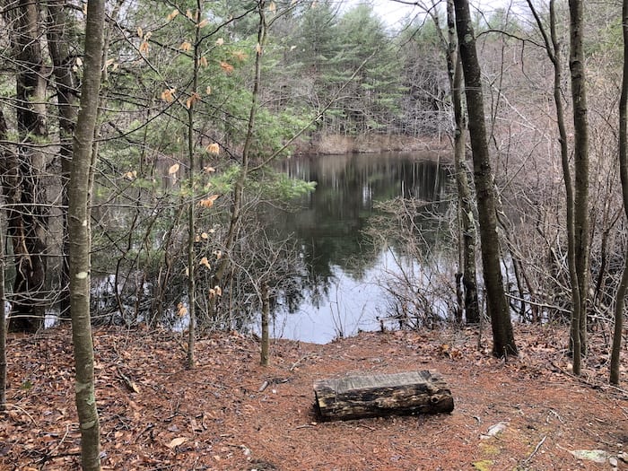
As soon as you leave the parking area, a massive field opens up with the trail forking almost immediately after the lot. Take a right on Twin Pond Trail along the right edge of the field, then after about a half-mile, take a right into the woods. This is an area in which you’ll probably want to simply wander, though the focus should be on the two bucolic ponds along the main trail. These ponds feel a million miles away from anywhere and as indicated earlier, very few people hike these paths, so you might have it all to yourself (one note, however—because there are so many trails, both here and in the Thompson Pond area, you really should have a printout of a map and also use a location-based mapping app such as AllTrails so you can not only see how to get to the ponds, but you can also find your way out, which is kind of important).
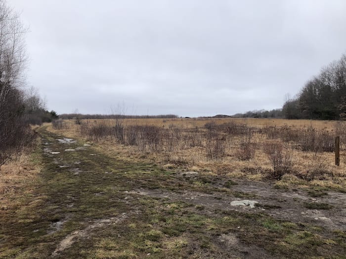
It is best to retrace your steps back to the field upon leaving the Twin Ponds area, cutting across the field rather than continuing right after emerging from the woods. After a quarter-mile, take a right, eventually noting the Thompson Pond Trail on the left which you’ll be taking later. Soon after that intersection, you’ll come to the start of a massive runway that seems to go on forever, and you may be wondering what this is; it’s actually an old US Navy airfield that was part of the South Weymouth Naval Air Station, and which may eventually be part of a brand new city (no joke), but for now it’s known as Union Point, or Southfield, which is its former name. This part of Union Point has a dusty and desolate feel to it, looking more like Nebraska or Kansas than the southern suburbs of Boston, with endless windswept grassy fields as far as the eye can see. It really makes for a hike or walk unlike any in the region, and there’s almost no chance of coming near anyone.
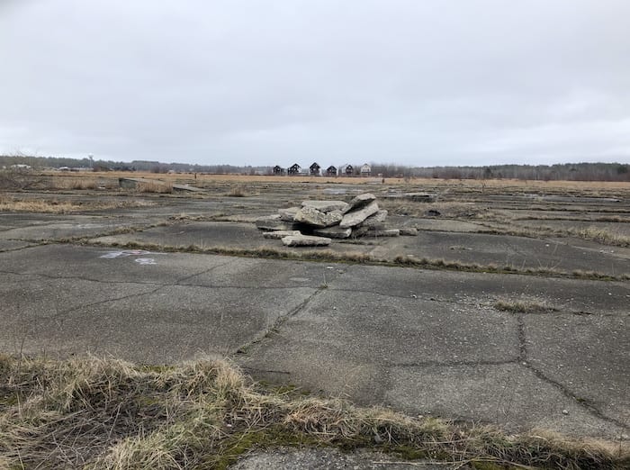
As you continue north on the runway, you’ll see what looks like a town center straight ahead; this is more or less the heart of Union Point, and other than a group of residential buildings, there isn’t much to it (whether Union Point will become a living, breathing city certainly remains to be seen). Looking to the left, you’ll see a couple of towers that were presumably part of the old base, and to the right, you’ll see….wait, what is that? A decrepit little town? A weathered old neighborhood slowly being swallowed up by the fields? Take the first runway that leads to the right and you’ll soon find yourself in an area that doesn’t seem real, and for good reason.
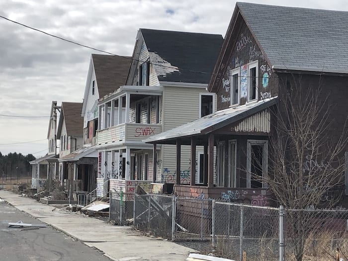
The 2016 movie Patriots Day, which was about the Boston Marathon bombing, had some of its scenes filmed at a studio space just south of the main part of Union Point, including one area that was meant to re-create Boylston Street in Boston’s Back Bay, and another that was a stage set of the neighborhood in East Watertown that was the site of the chase/shootout after the bombing. Both sets are still here, with the Boylston Street set being near the main road through Union Point while the Watertown neighborhood is set further back in the fields. If the fence is open, you can walk through the set, and it feels so much like East Watertown that, if it weren’t for the fact that the structures were mostly fake fronts and covered with graffiti (and in some cases, falling apart), you’d never know you were in a desolate field on the South Shore. Walking down “Laurel Street” is chilling in so many ways, and when you reach the end, you’re suddenly in the endless fields once again, which only adds to the unsettling feeling. But it’s a fascinating place and one that relatively few in the Boston area seem to know about.
Leaving the rather bizarre little neighborhood, head back to the left where you came from and then take another left down the runway away from Union Point, retracing your steps until you come to the aforementioned Thompson Pond Trail. After the weirdness of what you just saw, heading to the pond itself will quickly clear your head and much like with the Twin Ponds area, you can simply wander the trails along or near the pond, making sure that you know how to get back to the trailhead. Thompson Pond is much bigger than the two bodies of water you saw earlier, and there are several viewpoints where you can take a break, breathe in some fresh air, and wonder why no one else seems to know about this area (once again, it’s likely you won’t see anyone here).
Once you get back to the Thompson Pond Trail trailhead, take a right and you’ll quickly be back at the parking lot along Spruce Street. Go left and take a quick right into Rockland Town Forest and finish up at the bird sanctuary that you had been to a few hours earlier. After that, the picnic tables under the pine trees near the lot are a great spot to wind down and reflect on an admittedly odd but memorable hike that is just about as perfect a place for social distancing that you’ll find.
A trail map of Rockland Town Forest, Twin Ponds, and Thompson Pond can be found here.
An AllTrails breadcrumb map of most of this hike (not including the Watertown neighborhood, which is just to the right of the top of the breadcrumb trail) can be found here.

Marc is the founder of @hiddenboston, a textbook editor, a hike leader for @AppMtnClub, and a food and travel writer and commenter for DigBoston, NBC/NECN, WBZ, WMFO and indie617.