Aqueduct hiking may not be a thing (yet), but for those of you who are interested, you can do just that a few miles west of Boston
You may remember a hike mentioned here a while back where you could tell your friends that you walked across Boston Harbor, which, while not exactly true, made for a good story at the bars. (You can indeed walk from Squantum to the edge of Thompson Island at low tide via a sandbar.) A similar tall tale can be spun in the cities and towns west of Boston as well, and this one is equally odd, allowing you to hike on old aqueducts that, while mostly out of use now, can still be brought back to life in emergency situations. And no, if that were to happen, you wouldn’t be swept away (though that would make for a really good bar story), as the water actually runs through huge pipes underneath. But still, doing such a walk is sufficiently strange enough to help spin a good yarn over a beer or two—and in the case of the route given here, you’ll also find some of the most spectacular scenery in the entire Greater Boston area.
First, a little background on this particular route: The Sudbury Aqueduct was built in the late 1800s, being put in place to get water from the Sudbury River watershed to the Chestnut Hill Reservoir, at which point it would be distributed to people in and around Boston. Like some other aqueducts in the western suburbs, it is no longer in use except when there’s an emergency (and there was one a bit more than 10 years ago that necessitated just that), but much of it—along with other aqueducts nearby—is now used for recreation, including walking, jogging, and hiking. This particular aqueduct begins in Framingham and goes through Sherborn, Natick, Wellesley, Needham, and Newton, with these last three communities being the focus here.
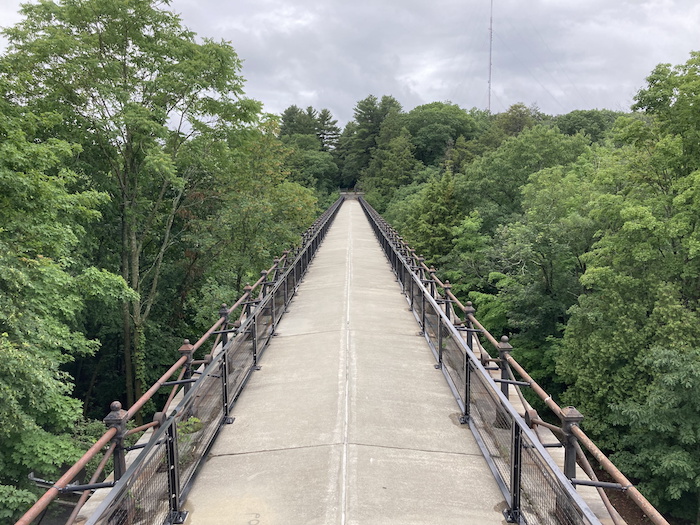
A good starting point for this hike is Newton Upper Falls, and whether you come by car or by bus, you’ll want to work your way up Chestnut Street between Route 9 and Elliot Street to a point basically across from Summer Street. There’s a little path here that looks like it might be someone’s sidewalk, but this is indeed the start of the hike. Within a minute you’ll probably find yourself saying, “Where the hell am I?” as you’ll suddenly be on top of a disturbingly high stone bridge looking down at a particularly wild part of the Charles River where it cuts through Hemlock Gorge. Some pretty rough waters can be found down below, but saving some of the best for last, this part will be looked at just before the end of the hike, so for now, soak in the views of the river from nearly 75 feet up.
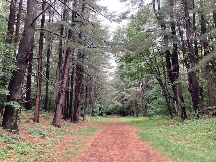
When you’ve had your fill of Echo Bridge, (and remember, you’ll get to see the gorge in all its glory later on), continue across the rest of the bridge where you’ll enter Needham with little fanfare, and continue straight until the path ends at Reservoir Street, where you’ll take a left. This is the one part of the walk that isn’t so much fun, as Reservoir Street ends at Central Avenue where you take a right and go under Route 128, emerging in a residential area. But you won’t be there long, as you’ll take your second right on St. Mary Street then walk about 300 feet at which point you’ll see a rather strange-looking walkway going in either direction that looks like it’s on a raised bed. This is the very same aqueduct that you were just on when walking over the Charles River, picking back up on the other side of Route 128. Take a left on the path and you’ll find yourself on an increasingly quiet trail as you get farther from the highway, getting deeper and deeper into the fields and woods of Needham. This stretch is actually called the Sudbury Aqueduct Trail and you can sense that you’re walking above a massive water pipe buried in the ground, almost feeling a little like you’re on a rail trail at times.
A bit less than a mile from where you entered the aqueduct trail, you’ll cross Cedar Street and suddenly find yourself on another street (Wellesley Avenue), and then—staying straight—on an access road to the John Eliot School. This is where a hike route app such as AllTrails will help, as the path follows the access road for a short distance, then continues straight as the road loops to the left but can be easily missed if you’re not looking. The aqueduct trail feels just briefly like a true rail trail at this point (albeit dirt, not paved), as it isn’t raised as much as at the start, though it soon becomes raised again. The woods really start to close in here, and after quietly entering Wellesley right about where you cross two more roads (Hunnewell Street and Comeau Street), you’ll find yourself approaching an old brick building right in the middle of the path. This is a control house that sits along the aqueduct, and while it’s locked up and off-limits to the public, it’s a rather fascinating structure, especially considering that it sits basically in the middle of nowhere.
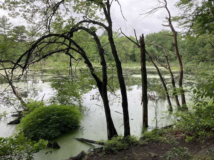
Just after the control house, the trail drops rather steeply. Around the bottom of the little hill, there is a trail that leads to the right. This is where you’ll leave the aqueduct trail for a little while, mainly because of the tremendous scenery that you’ll find on it and other paths to come. Almost as soon as you take a right, you’ll see a trail to the left that heads down to the water. Take this and follow it along the right edge of the wetlands, which is formed by Rosemary Brook. This is easily one of the highlights of the entire hike, as this unspoiled area will make you feel like you are miles away from civilization, and the path goes along the water for a good distance (nearly a half-mile) before turning away from the marshes and reconnecting with the trail that veered off the aqueduct trail initially, emerging at Oakland Street and the peaceful Longfellow Pond. Following the body of water counter-clockwise affords a number of great views, and after looping left around the north side of the pond then another left along the west side, you’ll come to a right turn that brings you to Priscilla Road. Take this road, following it to Priscilla Circle and then Putney Road, all the while noticing that you’re steadily climbing. A bit more climbing will soon come via Maugus Hill, along with scenes that look right out of something you might see in Vermont.
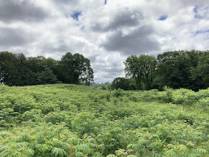
Putney Road ends at Oakland Street near where MassBay Community College resides, and at this point you’ll want to cross the street and bear left through a field, looking for a trail that heads down into the woods. From here it’ll really help to have that hiking app, as there are a number of paths here, but you’ll basically want to mostly keep bearing to the right in order to head up Maugus Hill. The summit, while relatively high for the Greater Boston area (at just under 350 feet) has no real views, but it is a quiet, tranquil spot that’s a great place to take a lunch/snack break. Heading back down initially on the trail you took up, take a right at Centennial Park Trail, which will loop you into an area of endless views of meadows and fields, a tiny pond, and then the lot for the park. From here, head left along the access road to Oakland Street, then right, returning to Longfellow Pond where you take a right either back onto the wetlands trail (off to the right) or the main wooded trail (straight) back to the aqueduct trail just down the hill from the control house.
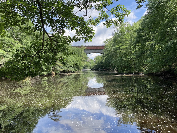
If you’re short on time, you can retrace your route all the way back to your car (or the bus) in Newton Upper Falls, but you really need to set aside some extra time for the very last leg of the journey, which may be the best part of the entire trip in some ways. After crossing under Route 128 once again, avoid taking a left back onto Reservoir Street, instead continuing on Central Avenue for one block to Hamilton Place where you’ll see a gate off to the right. Pass through this gate and take the trail that parallels Hamilton Place, which is a few yards to your left, then at the trail fork, take the path that bears left up the hill. This soon crosses the trail that goes onto Echo Bridge (which will be to your right) and, staying straight, drops down to the water, crossing onto a peninsula with marvelous views of both the Charles River and the bridge. It’s a must if you have a good (or even a bad) camera. The path soon reaches the ramp off Route 9, but you’re not done with the scenery just yet, as a booming waterfall is located here, while a narrow cascade of water sits a bit farther down as you head to the right. The trail then ends at the parking lot, which marks the end of the hike if you drove; if you took the bus, take a right up Ellis Street then down Chestnut Street, which will bring you to your stop.
It seems strange that a hike so close to Route 128 could be so rugged and remote-feeling, but you’ll certainly feel like you’re many miles from the Boston area during much of this walk. By the way, if you’re intrigued by the aqueducts, there are other such trails hidden away in Newton, Wellesley, Wayland, Weston, Natick, and elsewhere in the western suburbs, so get ready to do much more exploring if you’re so inclined. [Ed note: The Appalachian Mountain Club Local Walks/Hikes group (of which I’m a leader) occasionally has hikes in these parts of Newton Upper Falls, Needham, and Wellesley; a link to the group can be found below.]
Directions
By car: Take Route 128/95 to Route 9 east [Exit 20A(old)/36A(new)], then take the first right down the ramp at the William Street/Chestnut Street exit. At the stop sign, take a right onto Ellis Street and an immediate left into the parking lot.
By public transportation: Take the Green Line (D) to Newton Highlands then the 59 bus toward Needham Junction to the Chestnut St @ Elliot St stop, or take the Needham commuter rail from South Station to Needham Junction, then the 59 bus toward Watertown Square to the Chestnut St @ Elliot St stop.
mwra.com/access/aqueducts.html | newtonconservators.org/property/hemlock-gorge | amcboston.org/committee/walks

Marc is the founder of @hiddenboston, a textbook editor, a hike leader for @AppMtnClub, and a food and travel writer and commenter for DigBoston, NBC/NECN, WBZ, WMFO and indie617.