360-degree views of the city and a whole bunch of history.
As some of you may recall, a bit more than a year and a half ago a group of us hiked up the highest “peak” inside Route 128 to a weather observatory, an event held by the Appalachian Mountain Club and led by yours truly. This was actually a co-lead of sorts, as I led the hike part of it and Eric Fisher (who is the Chief Meteorologist for WBZ/CBS Boston) and our observatory tour guides gave the group fascinating info on weather, climate, and the history and layout of the observatory building. Lost in all of this was the fact that Great Blue Hill itself is a pretty special destination spot, one that is often overlooked even though it is only about two miles from the Boston line. Well, now we look at Great Blue in more detail, thanks in part to a trip we took there recently—and a place we have hiked to countless times over the years as well, including for the AMC.
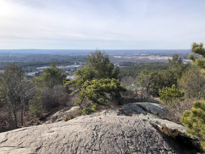
The city of Boston basically sits in a bowl, with hills and ridges to the north, west, and south reaching several hundred feet in spots, including the Blue Hills Reservation whose ridge looks a bit like a wall to the south. Here you will find a number of hills that surpass 400 feet in height, including Great Blue, which is the highest of them all, checking in at 635 feet above sea level. This may not sound like much to folks in northern or western New England, but considering how close the Blue Hills are to the ocean, it is actually one of the highest points between the Southern Maine coast and the tip of Florida. Because of its prominence compared to other hills in the Blue Hills and elsewhere in the immediate area, the views are mostly unimpeded and always spectacular, and while a couple of trails that lead to the top can get awfully crowded, there are ways to reach the summit without seeing many people at all, including one that is extremely challenging and another that is a breeze to do.
As was the case with the observatory hike, our latest hike up Great Blue was done via the easiest route, taking the green dot trail from the parking lot on Route 138 that is just north of the Trailside Museum (the one after the main lot for the ski area), with the green dot including parts of the Wolcott Path, the Puddle Path, and the Wildcat Notch Path, where you then take a sharp right and head up the Coon Hollow Path (which is a red dot trail) and soon reach the part of the summit that is home to the Eliot Tower. This section of Great Blue Hill can get awfully crowded on a nice day, which is maybe not what you want to deal with during a pandemic, but if the tower isn’t too packed it is well worth climbing for nearly 360-degree views that include the Boston skyline to the north, the vast undeveloped lands of the Blue Hills Reservation and the ocean to the east, some low hills and suburban areas to the south, and—on a clear day—views of a few mountains well to the west and northwest, including Mount Wachusett in the central part of the state, which has an elevation of just over 2,000 feet.
The Eliot Tower area has a real high-mountain feel to it in part because of the tower’s stone base that looks like a patio and has picnic tables where hikers can enjoy a bite to eat or just catch their breath before continuing on. The tower, base, and nearby stone bridge were all built by the Civilian Conservation Corps (CCC) which was set up by President Franklin D. Roosevelt back in the 1930s as a work relief program during the Great Depression. And while most hikers opt to do the summit loop from this point—perhaps taking a side trip to the observatory on the other side of the summit—there is actually a little-known trail that starts behind the base of the Eliot Tower, and this is the route we took, winding our way through some unspoiled woodlands right in the heart of Great Blue’s massive summit, emerging from the woods at the observatory and the true summit of the hill.
Unlike our trip in the summer of 2019, we weren’t looking to do a formal tour of the observatory this time around, but the castle-like building was quiet when we arrived and an acquaintance who works the tower was there that day, so we had a quick visit with him. (The public is only allowed to visit the observatory tower via a guided tour, though the gift shop is open to all.) The observatory tower consists of a history/library room on the first floor, the actual observatory/computer room on the second floor, and an observation deck on the top floor where you can see some of the same views that the Eliot Tower affords, though it is more open and is home to some weather-related equipment, such as a sun recorder that smells a bit like marshmallows(!) as it burns sunlight onto paper cards to record the amount of sunshine each day. It can’t be overstressed how fascinating the observatory is, so if you feel comfortable doing a tour (or wait until the pandemic subsides), it’s an experience that you won’t soon forget.
The grounds of the observatory are quite interesting as well, as it includes a fenced-in instrument enclosure used to measure temperature, snow depth, and more, a picnic table off to the side with stunning views of the valley below, a plaque outside the observatory entrance that shows info that only a weather geek could love, and an open field with a number of birdhouses. We took the narrow trail behind the observatory that took us past the birdhouses, soon arriving at the summit trail where we took a right and a quick left onto a piece of the Skyline Trail that, to be honest, isn’t for the faint of heart. This is the aforementioned “challenging” trail that some seasoned hikers climb up from Route 138 to train for the big peaks up north, and heading down the path from the summit can be downright dangerous if the rocks are wet. We only went down the first 100 yards of it because this part of the trail opens up onto a few ledges where some of the best views from Great Blue can be found and is another great place for a picnic lunch if the winds aren’t too strong.
Retracing our tracks, we returned to the summit loop and took a left, going clockwise with the ski area to our left, eventually taking a side trail to where one of the chairlifts drops off skiers and snowboarders. You’re not allowed to get too close to the lift when they are running, but the views from just before the lift are pretty memorable, and if the lifts aren’t running, you can walk over to the top of the ski trails for a completely different perspective of the hill. Returning once again to the summit loop, we made our way back to the Eliot Tower and retraced our steps along the easy route and back down to the lot, encountering some crowds by the tower but soon being mostly alone in the woods on the way down. By the way, if you want more of a challenge, not only can you climb the extremely challenging part of the Skyline Trail from Route 138, but you can also take the north or south fork of the Skyline Trail over by the Eliot Tower, both of which are pretty steep as well. For a more moderate hike, the two branches of the red dot trail from the Trailside Museum will get your heart pumping while also not being too difficult, but these trails tend to get very busy so keep that in mind before mapping out your route.
So much of the Blue Hills should be considered if you are a hiker (or are interested in taking it up), with other highlights being such peaks as Buck, Hancock, Hemenway, Rattlesnake, Little Blue, Hawk, Nahanton, Chickatawbut, Wampatuck, and the tough-to-find Kitchamakin, while bodies of water such as Houghtons, Ponkapoag, St. Moritz, Hillside, and the Blue Hill Reservoir are must-sees as well. But Great Blue is really something special, and if you can find a way to hike it on a weekday or early/late in the day, you may also get the type of solace that hikers often strive for, which is a truly great feeling when you’re so close to the hustle and bustle of the city just to the north.
Website for the Blue Hills Observatory

Marc is the founder of @hiddenboston, a textbook editor, a hike leader for @AppMtnClub, and a food and travel writer and commenter for DigBoston, NBC/NECN, WBZ, WMFO and indie617.